Canoeing the Park River Under Hartford

The Park River once flowed past the the Connecticut State Capitol’s gilded dome and was the centerpiece of its namesake, Bushnell Park, in downtown Hartford, but it is now mostly forgotten. After the floods of 1936 and 1938, it was decided that the river should be buried to prevent future flood damage. Under the direction of the United States Army Corps of Engineers, construction started in late 1940 to entomb the river in dual 20 foot by 30 foot concrete conduits from the Connecticut River to the Capitol, and finished in 1944. While this conduit worked well, it was decided that more of the river needed to be buried after the flood of 1955, and the Greater Hartford Flood Commission was established soon thereafter. During the construction of Interstate 84 during the 1960s, the State Highway Department built additional sections of conduit under the direction of the Flood Commission. The final sections of conduit, as well as an auxiliary tunnel to the Connecticut River, were built by the United States Army Corps of Engineers under the Park River Local Protection Project, which was authorized in 1968, with construction finishing in 1981. In total, almost four miles of river are buried, plus an additional two mile long auxiliary tunnel.

Original Conduit Excavation and Invert Construction (from Hartford Engineering Dept. Report) Continue reading

Posted in | Tagged , , , , | 43 Comments

Volume of West Hill Pond

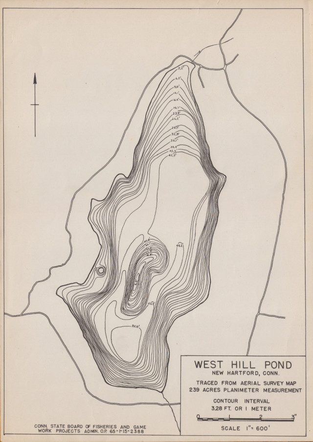
Since I have a bathymetric map of West Hill Pond, I thought it might be interesting to calculate the volume of the pond. The formula for calculating the volume of the frustum of a pyramid is V = \frac{1}{3} h \left( A_1 + A_2 + \sqrt{A_1 A_2} \right) where h is the height of the frustum, A_1 is the base area of the top of the frustum, and A_2 is the base area of the bottom of the frustum.1 This formula can be used with bathymetric contours to approximate the volume of a water body.2 Applying the formula to the bathymetric map of West Hill Pond results in a calculated volume of 9.3 × 10⁶ m3, or 2.5 billion gallons.

West Hill Pond WPA Bathymetry

Also available is the bathymetric contour shapefile used.


  1. Conical Frustum — from Wolfram MathWorld 

  2. Taube, Clarence M. 2000. Instructions for winter lake mapping. Chapter 12 in Schneider, James C. (ed.) 2000. Manual of fisheries survey methods II: with periodic updates. Michigan Department of Natural Resources, Fisheries Special Report 25, Ann Arbor. 

Posted in | Tagged , , | Leave a comment

NavSpark / XBee Adapter

As I wrote last month, I recently got a set of NavSpark NS-RAW receivers. These can be used as a RTK GPS receiver system, but some sort of data link is needed. For shorter distances, XBee modules work well. Since I needed a convenient method for connecting the two devices together, both for the base station and the rover, I created an adapter board.

Front of NavSpark / XBee Adapter

Continue reading

Posted in | Tagged , , , , | 9 Comments

NavSpark versus NS-RAW

Today I received the NavSpark and two NS-RAW GPS receivers I preordered from SkyTraq back in January. The NavSpark is a programmable SPARC-based GPS receiver, while the NS-RAW is one of the cheapest GPS receivers available with raw measurement output for RTK positioning. In recent months, it became clear that the two receivers would be virtually identical hardware-wise, just with different firmware.

On receiving the boards, the first thing I did was look for the differences. The most obvious difference is that the NavSpark has version 1.4 of the PCB, while the NS-RAW is built using version 1.3. The only difference I could find between the revisions is that version 1.3 left out the pull-up resistor on the SDA I2C line. SkyTraq seems to have used the flawed boards for the NS-RAW since it is not supposed to be programmable and thus won’t make use of I2C. This extra resistor can be seen below; version 1.3 is on the left, while version 1.4 is on the right.

Version 1.3 (left) versus 1.4 (right) Continue reading

Posted in | Tagged , , | 2 Comments

CHDK on the Canon PowerShot ELPH 330 HS

I recently purchased a Canon PowerShot ELPH 330 HS point and shoot camera to replace my aging Canon PowerShot SD770 IS. The new camera has better sensitivity, a considerably wider field of view that will help with aerial photography, and more zoom. However, it did not have CHDK available for it, which I was aware of at the time of purchase. The first thing I did on receipt of the camera was begin porting CHDK to it. A few weeks later, the port was mostly done, and it was recently merged into the trunk.

Canon PowerShot ELPH 330 HS with CHDK

Posted in , | Tagged , , , | 6 Comments