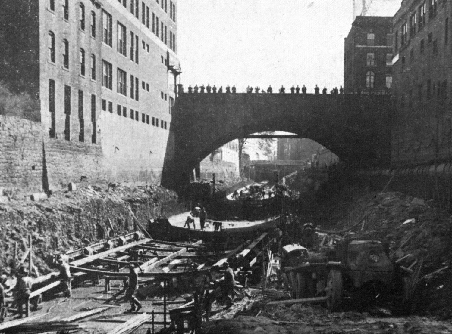
The Park River once flowed past the the Connecticut State Capitol’s gilded dome and was the centerpiece of its namesake, Bushnell Park, in downtown Hartford, but it is now mostly forgotten. After the floods of 1936 and 1938, it was decided that the river should be buried to prevent future flood damage. Under the direction of the United States Army Corps of Engineers, construction started in late 1940 to entomb the river in dual 20 foot by 30 foot concrete conduits from the Connecticut River to the Capitol, and finished in 1944. While this conduit worked well, it was decided that more of the river needed to be buried after the flood of 1955, and the Greater Hartford Flood Commission was established soon thereafter. During the construction of Interstate 84 during the 1960s, the State Highway Department built additional sections of conduit under the direction of the Flood Commission. The final sections of conduit, as well as an auxiliary tunnel to the Connecticut River, were built by the United States Army Corps of Engineers under the Park River Local Protection Project, which was authorized in 1968, with construction finishing in 1981. In total, almost four miles of river are buried, plus an additional two mile long auxiliary tunnel.
More than two years ago, I decided I wanted to canoe the Park River and started researching it. While other people had explored it and tours were even given at one point, I couldn’t find much detailed information online. Therefore, I proceeded to acquire copies of the engineering reports on the Park River Local Protection Project via interlibrary loan and looked at maps and other reports at the Connecticut State Library, which gave me a much better understanding of the conduit system.1
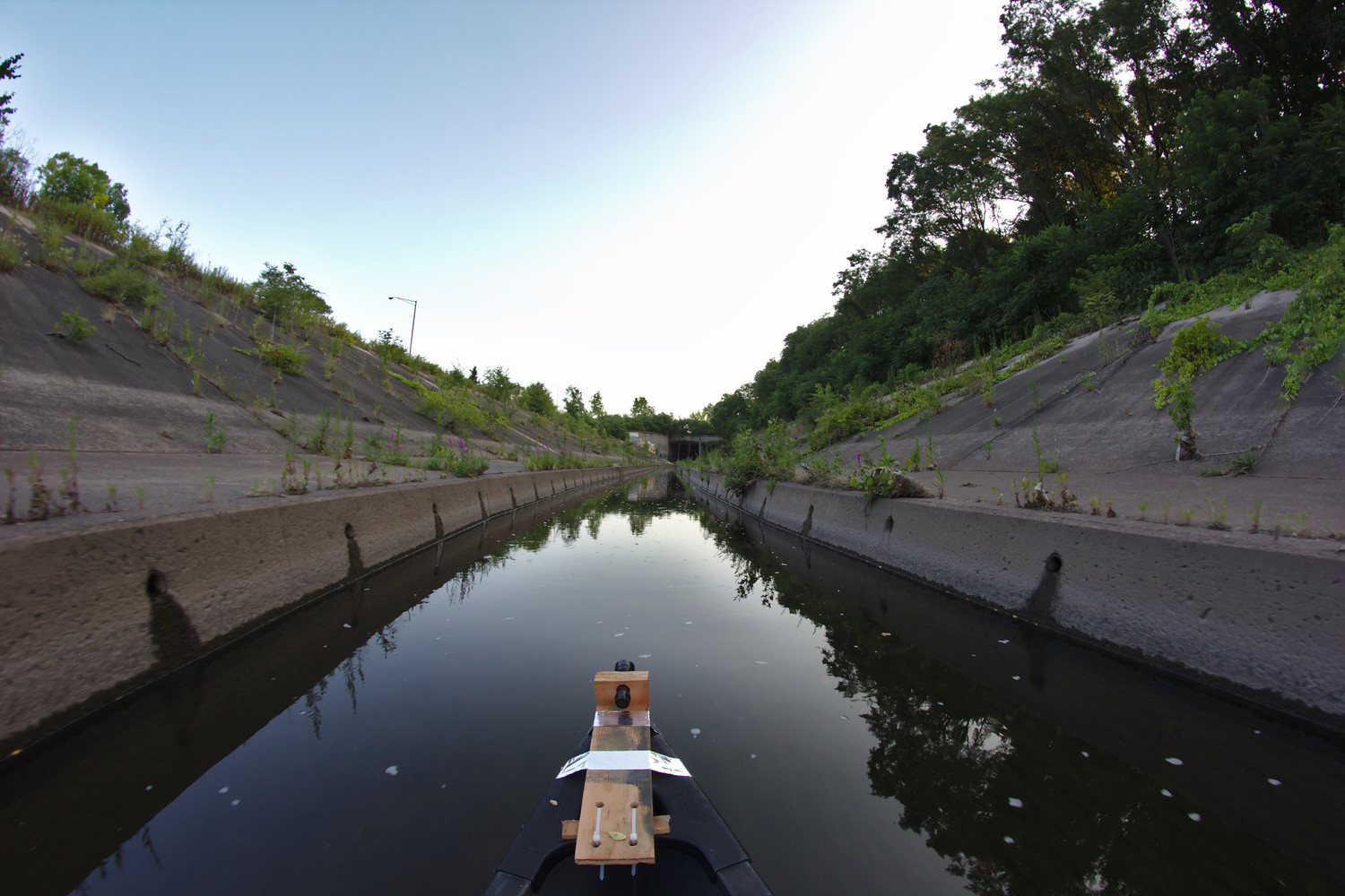
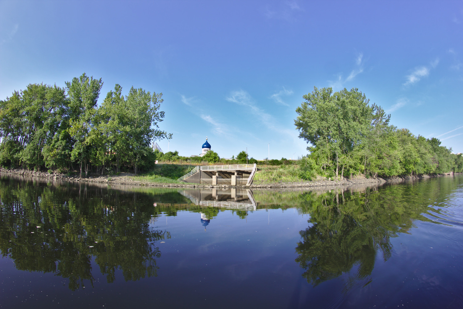
A few days ago, I put this knowledge to use and finally paddled under Hartford. The river has a North branch that goes into the conduit near the Mark Twain House and a South branch, which I took, that goes underground between I-84 and Pope Park. While the river is fenced off, there is a convenient hole in the fence on the East side of the river just North of the corner of Hamilton and Brookfield streets, as well as an open gate farther North. Arriving in Hartford a little after six on a Sunday morning, my canoeing partner and I dropped off our canoe, chaining it to a fence post; staged a car at Charter Oak Landing; and returned to Pope Park. We then began our hour and a half journey through the bowels of Hartford to the Connecticut River.
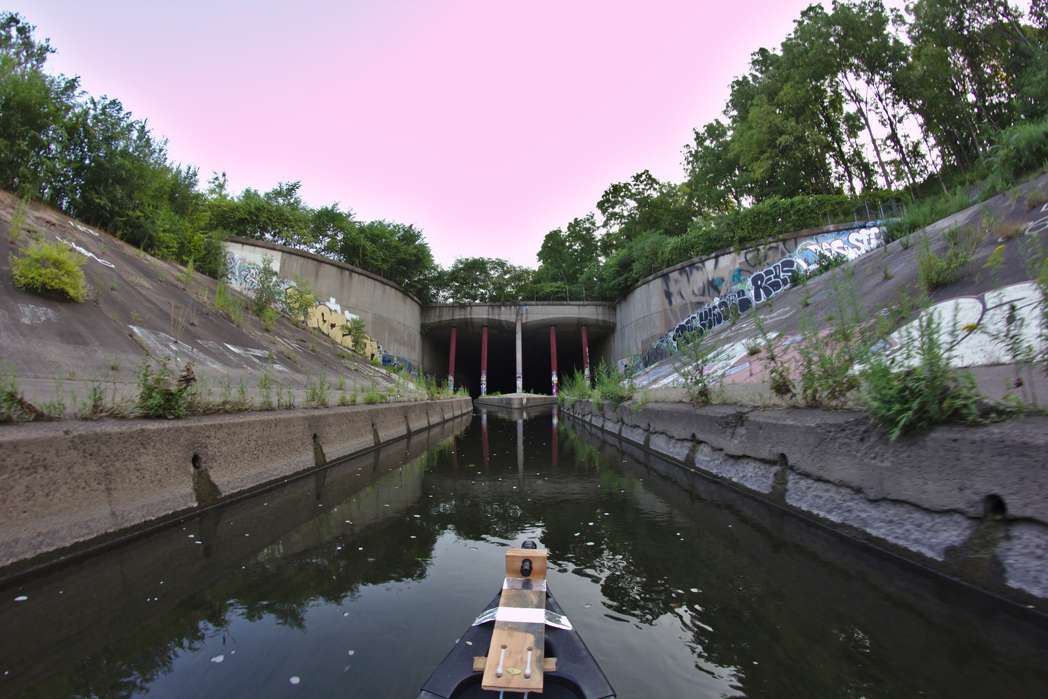
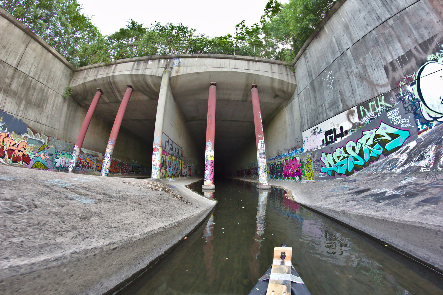
Launching our canoe in about a foot of water in the river’s concrete channel, we began paddling towards the conduit’s mouth a quarter mile away. As we got closer, the conduit’s massive twin entrances appeared, where we opted for the right tunnel. Light reaches a few hundred feet into the tunnel, until the first turn; as the light fades away, so does the graffiti. The river was fairly low, with the North Branch discharge gauge reading 4.2 ft3/s; while traveling through the conduit with high water is an extremely bad idea,2 a little more water would have been nice as we bottomed out on debris and sediment a few times and had to walk the boat part of the way, although this was easy as one could walk along the sides of much of the conduit and be out of the water. Also, life jackets are always a good idea.
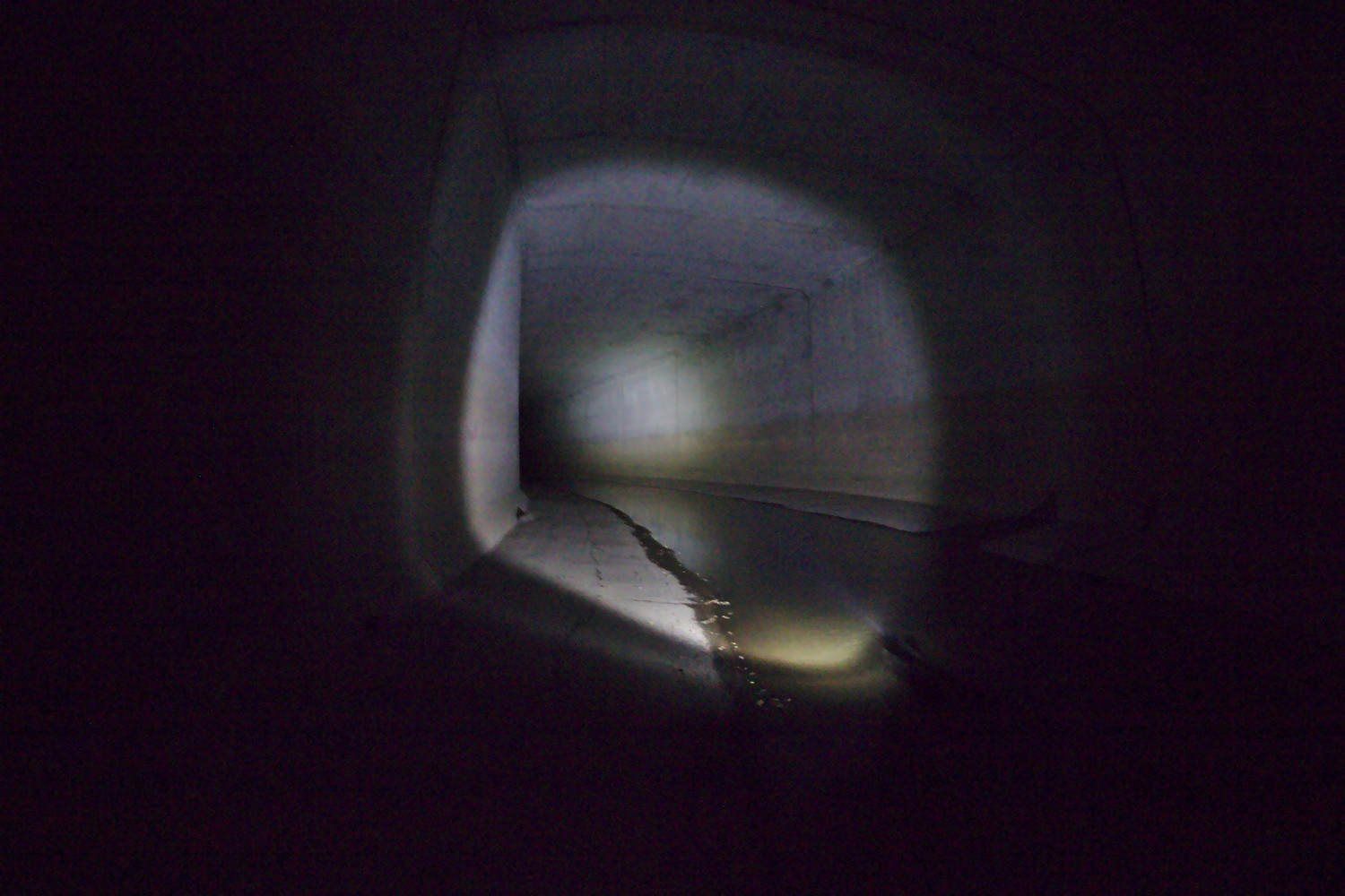
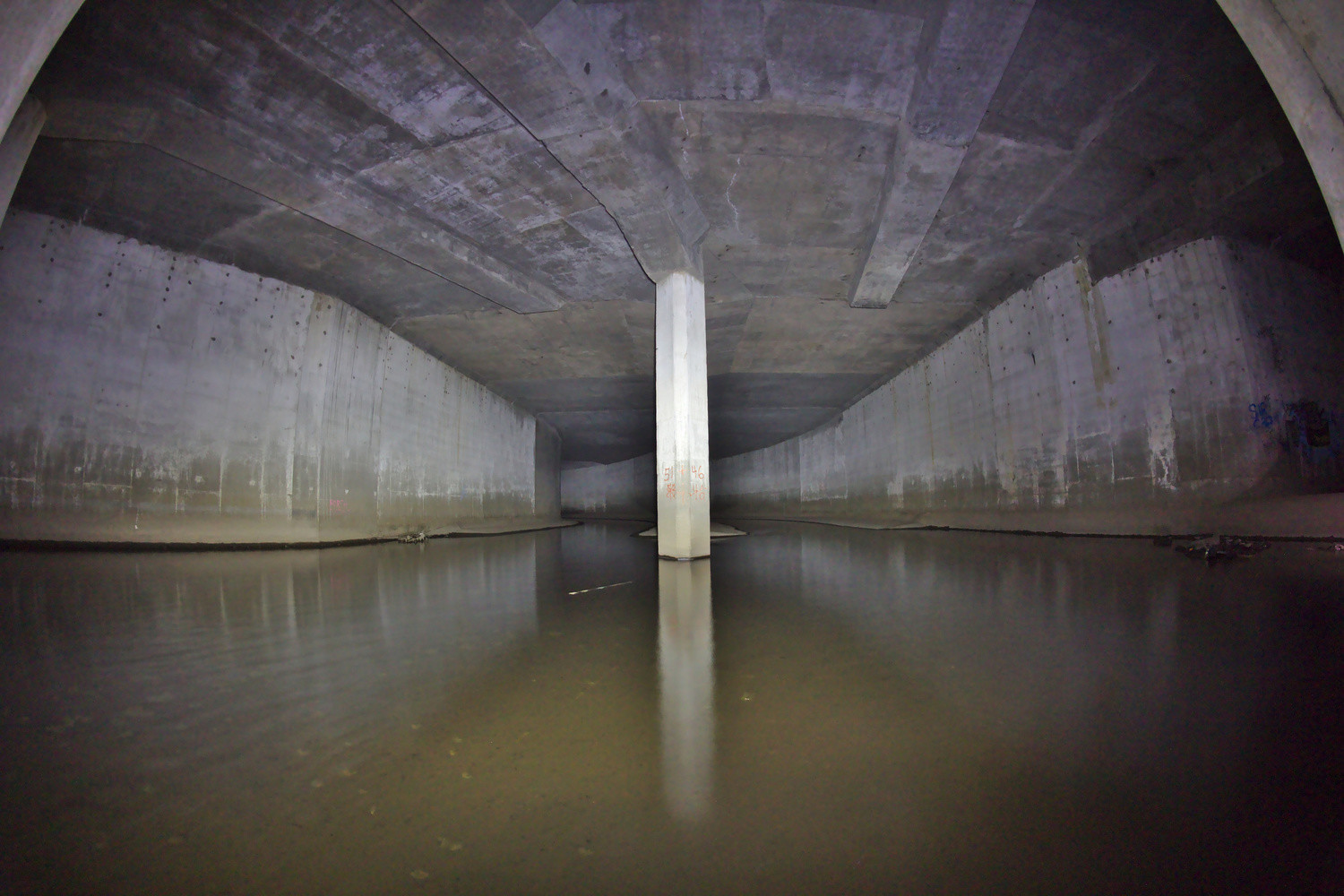
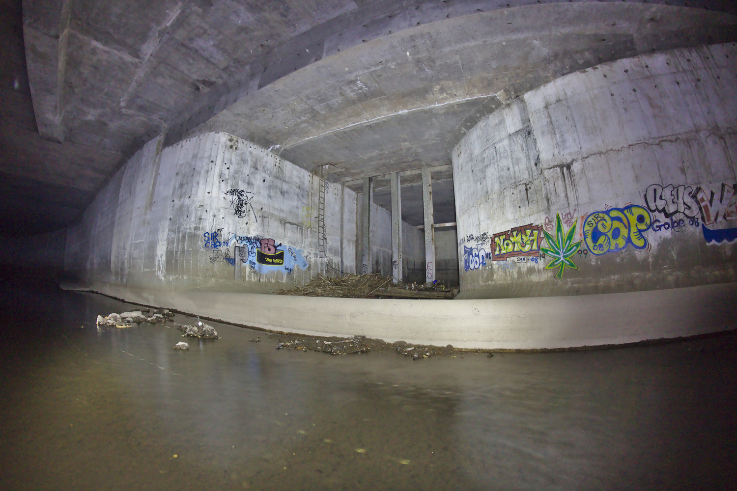
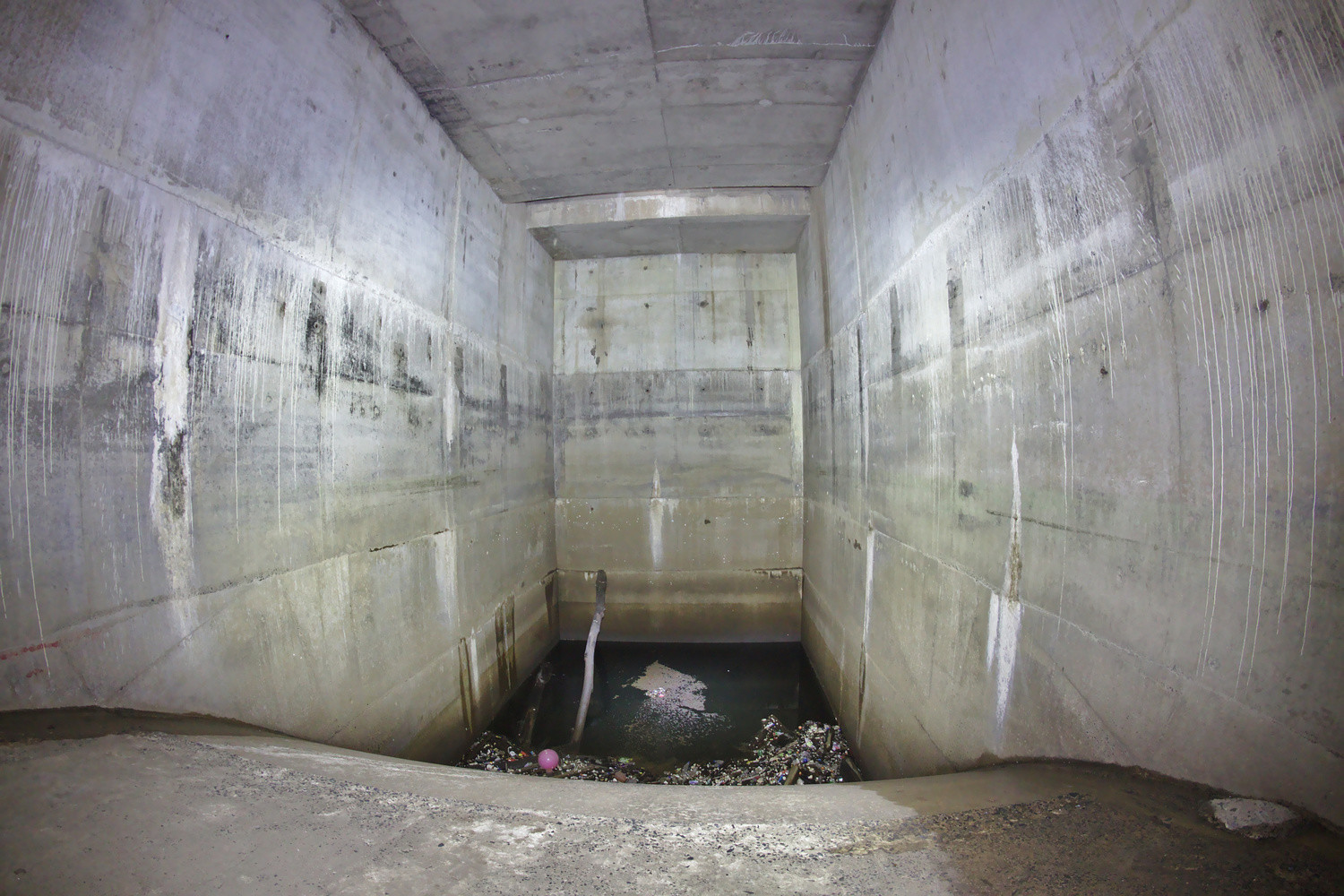
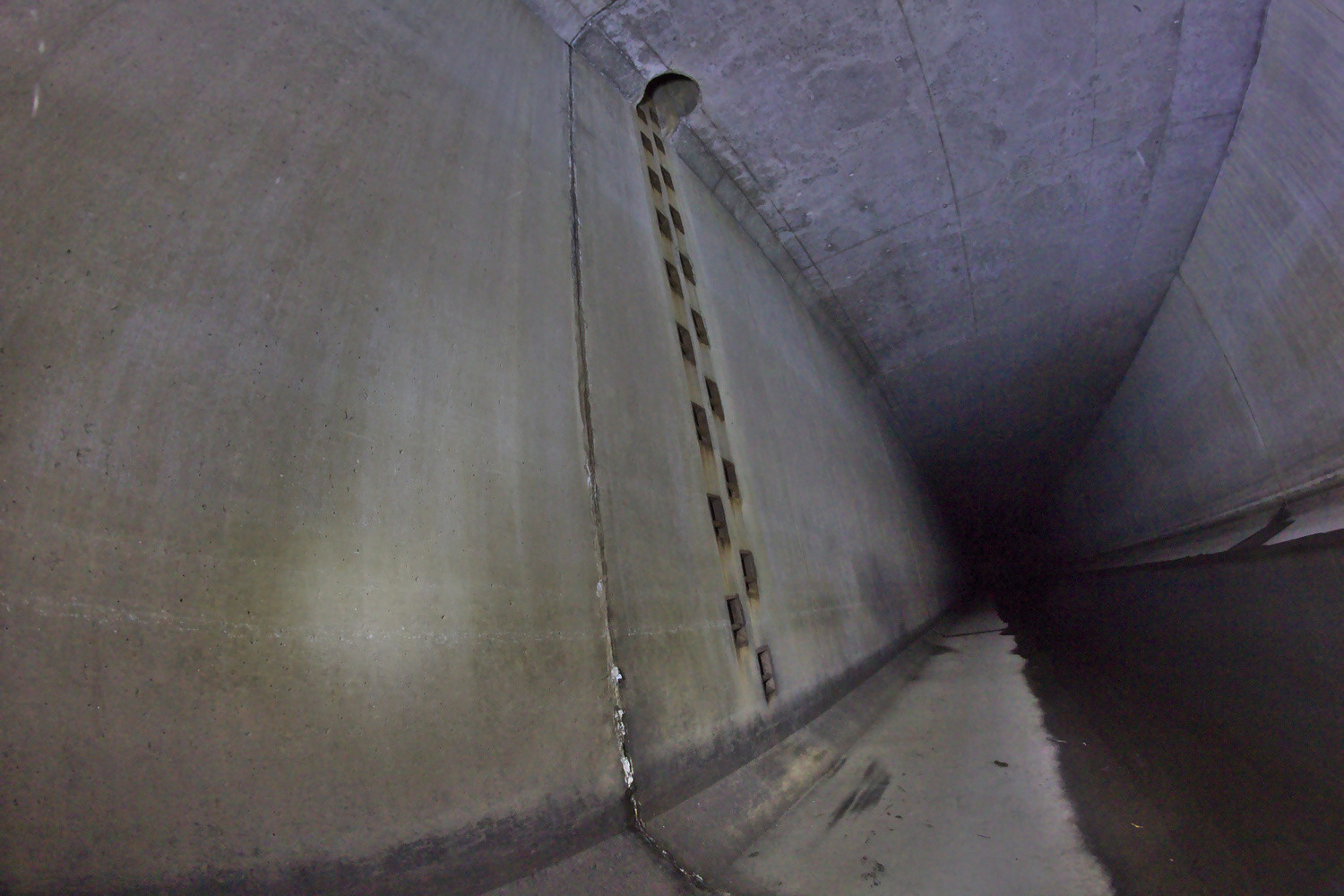
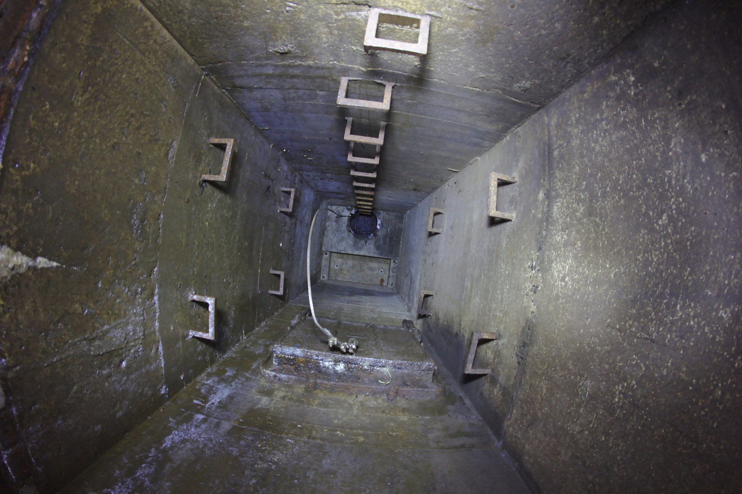
As one continues into the tunnel, flashlights become the only light source, and we used a high-power, 900 lumen LED flashlight mounted on the front of the canoe as a headlight. Roughly 1500 feet into the tunnel, we came upon the junction structure, a massive concrete chamber where the North and South branches meet. To the right, up a few foot concrete ledge and behind massive steel tree catchers, is the auxiliary conduit. Dimly illuminated with light from the conduit system’s only vent, is a pool of stagnant water at the bottom of a steep slope, the entrance to the auxiliary conduit; one shouldn’t get too close, as it would be very difficult to get out if one were to fall in.3 The auxiliary conduit is of an inverted siphon design, like the U on a sink drain; it drops below sea level, travels through bedrock, and returns to the surface next to the Connecticut river, making it near impossible to traverse.
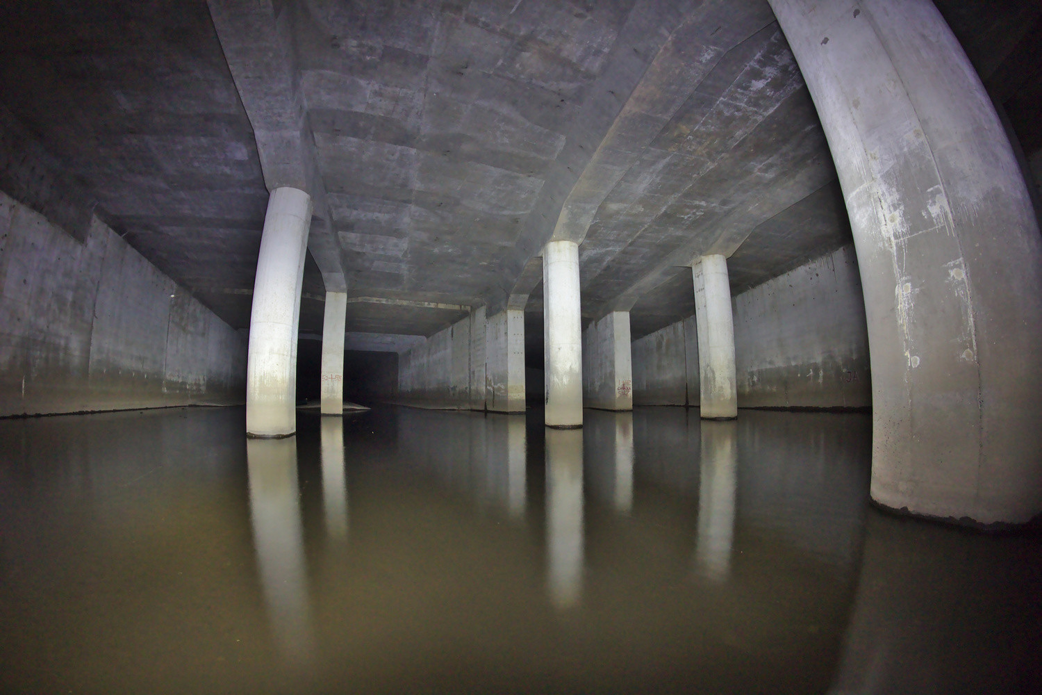
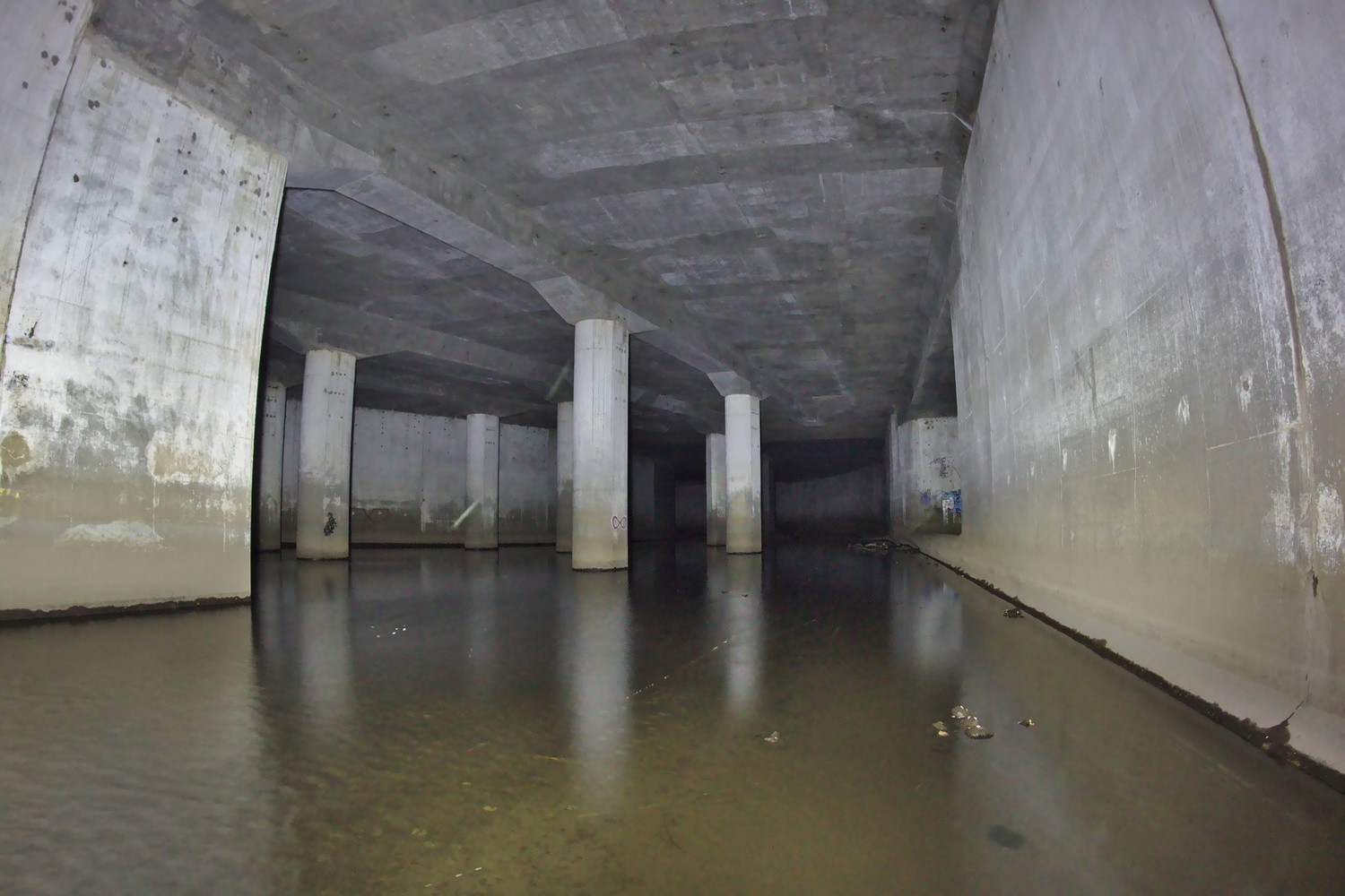
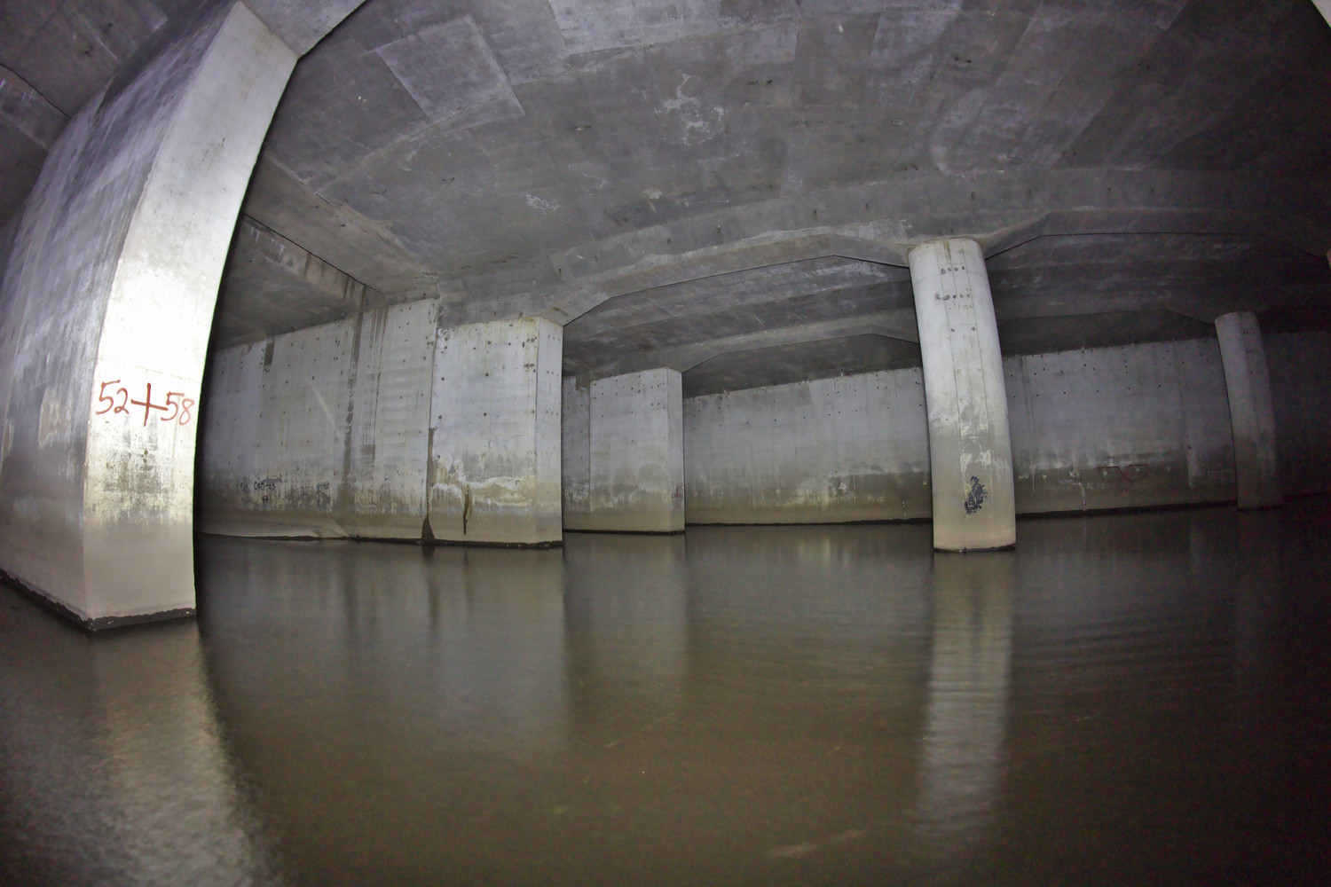
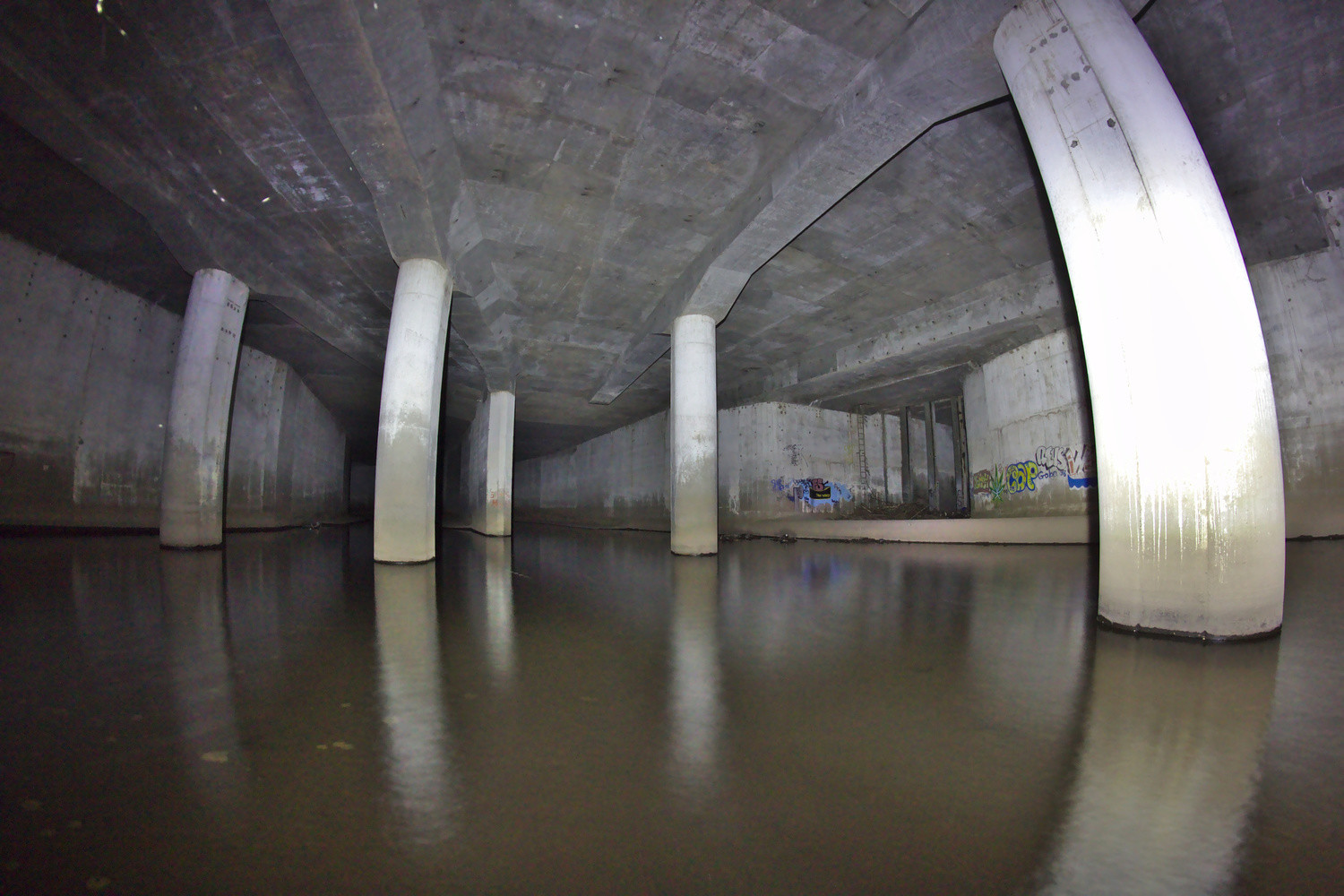
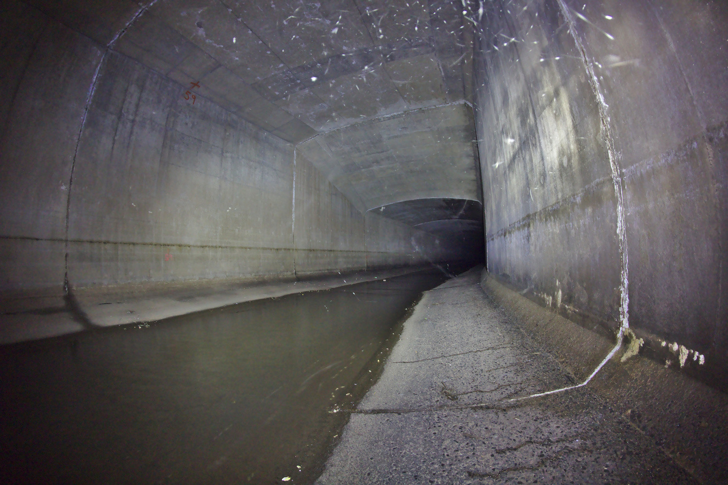
Leaving the junction structure, one should take the right tunnel, as the left tunnel has unpredictable discharges from Hartford Steam that shoot horizontally out into the conduit.4 Besides for occasional debris, it was mostly smooth paddling as we headed toward Bushnell Park. Various pipes drain into the conduit, and their trickling water can be heard from quite a distance, echoing down the tunnel. Additionally, there were occasional access ladders going to the surface. Just after one of these access points, there were even some work lights strung along the center of the ceiling that were left up, with the plugs on the ends dangling down. If one is observant, one can see the transitions from the sections of conduit built in the 60s to those built in the 70s, as the concrete color changes and painted over graffiti by the old entrances is visible. Otherwise, the sections built in both decades are pretty similar, although one section from the 60s, under I-84, has concrete beams reinforcing the ceiling.
As the conduit transitioned to the original section from the 40s, just North of the Capitol, the ceiling dropped from a little under 30 feet to a little under 20 feet, the grade steepened, and the water became faster and shallower; the concrete was noticeably more worn than the previous sections. Here, under Bushnell Park, we again walked the boat as the water was too shallow, and the canoe was scrapping along the channel bottom. Around Main Street, the conduit levels out and the water deepens as the conduit reaches the level of the Connecticut River. Here was where most of the debris we encountered was, including a car and a few shopping carts. The sedan was flipped upside-down in the middle of the conduit in about three feet of water and has apparently been there for a few years.5 It was probably stolen and driven much of the way down the conduit as the water was only about a foot deep until shortly before the car’s present location; flood waters likely then pushed it to its current resting spot. While there was less debris than expected, there was also more wildlife. I spotted catfish and an eel while wading in the junction room, and there were swarms of gnats under Bushnell Park, but most surprising was the duck we saw. Past the junction room, thousands of feet into the tunnel, we encountered a duck that kept flying farther and farther into the tunnel away from us. Although we thought we would end up chasing it to the Connecticut River and out of the conduit, it eventually stopped flying away from us, and we were able to pass it.


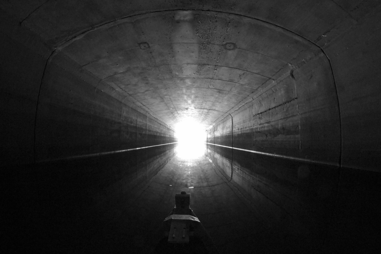
When we started our subterranean journey, the air temperature was just right for paddling in a T-shirt and swim trunks, probably in the lower 60s. As the water deepened, the air became cooler, which was refreshing after having paddled for over an hour. Traveling under the Whitehead Highway, the ceiling became lower and lower as we progressed towards the Connecticut River, but eventually a prick of light appeared. We paddled toward the light at the end of the tunnel and emerged into the bright morning sun. We proceeded down river to Charter Oak Landing, where we got out, passing the exit of the auxiliary conduit; loaded the canoe on the car; and left. The trip was a fascinating experience; it was neat seeing the massive physical object that the engineering reports I had read described, and the expedition was well worth it.

The following United States Army Corps of Engineers reports are now online: Plan Formulation, Box Conduit Design, Auxiliary Conduit Design, Auxiliary Conduit Detailed Design, Auxiliary Conduit As-Built Main Report, and Auxiliary Conduit Appendices. They contain some interesting maps and drawings, particularly the box conduit design report. Noteworthy items in the State Library include a 1981 MDC map, G3783.H3 1983 .M4; Hartford Department of Engineering reports to the Court of Common Council, H251eng; and parts one and two of a Report to the Greater Hartford Flood Commission upon Control of Floods in Park River from 1958–1959, G78 me. The MDC map shows the location of the conduit, the engineering department reports mention construction progress and contain photos, and the 1958–1959 report contains details about the original conduit as well as drawings for a proposed expansion, some details of which were used for the final design. There is also apparently a report by the same engineering firm that produced the last item, Metcalf & Eddy of Boston, from the construction of the original conduit, although I was unfortunately not able to locate a copy. ↩
If the water level in the Connecticut River is too high, you can’t get out. ↩
Without a rope, that is. We brought a throw bag as a safety precaution. ↩
See slide 16 of the Life in a Conduit presentation. ↩
A blog post from 2011 mentions it. ↩
Matthew, this is the best source for info on the Park River I could find. Nice job.
Well now….I believe that I am one of very few who actually read this entire article. I was born in Hartford in 1939 and always thought it was a great place to live…even if occasionally unpredictable. It’s my home town and I still love it.
fabulous adventure!
Can one of the many people coming here from Facebook please tell me where the link to this post was shared? I’ve seen a huge spike in visits from Facebook, 2k+ this week so far, but have been unable to find a link on any public Facebook page. Thanks.
This guy had it posted originally – “Derek Schwalenberg” – and a friend of mine shared it…. Sounds like an awesome adventure man, and brave – for a variety of reasons!
i seen it posted just now in a group called ‘abandoned and neglected Vehicle’s’
I found the link to this web post on a Facebook page for “Abandoned and Neglected Vehicles.” The poster showed your picture of the underwater car and added a link to this article for credit of the picture, I believe. A very interesting read, I enjoyed sharing your adventure! Thanks. :)
I linked from the West End Living FB page.
Such a cool article! I never knew this existed. Love the description of the journey as well as the pics. Thank you!
Very, very cool!
Matt, in answer to your question; there was a single link directly to this site from a friend. I think it’s just getting shared a lot. Enjoy the notoriety, seems like a cool thing to do and I may just have to try it.
Jon
I grew up on Woodbine St. It was a dead end because of the river. My family and I watched some of the construction being done to the river. We never knew about the completion or how they did it. Thanks for doing the research. I appreciate it. Suzanne Lavoie
Matt…I would love to do this canoe trip this summer if possible. Do you do tours? Please let me know as I’ve been fascinated by the underground river for many years. Craig
I don’t do tours and probably won’t even be in Connecticut this summer. Sorry.
Absolutely fascinating. I felt as though I was taking a trip with you while I was reading this. Thank you for sharing.
Wow, what a journey you guys had. I always wanted to do it, but your photos have taken me there, without having to paddle it. I did some photos for a book, that a friend of mine wrote about the history of the Connecticut River ( the Connecticut section only ) and he was some photos of the entrance coming out of Hartford, into the river. I was in a kayak and used a smaller light and went into the right side of the tunnel. I only went in about 300 yards and the noises I heard in front of me sounded like a “chopping machine”, so I made my way out…I enjoyed reading your information and story….Kiddos to you guys….Jeff Feldmann
Awesome article and the best info out there on Park River. My friends and I were considering doing this and now we have some great info to go by if we do.
At what discharge rate would you recommend being the limit? Right now the river is still a little high from earlier flooding. It’s at 24 ft3/s. (down from 600 a week ago! :))
I don’t really have a feel for the flow rates, so I can’t give a number, but I wouldn’t recommend it if the water is overflowing the center, low-flow channel on the approach to the conduit.
Thanks Matthew for such a well documented look at the Park River under Hartford. I have been in there on a few different occasions, been in from the CT river side up to the vicinity of the pump house in Bushnell Park, and I’ve been in from the Pope Park end on a bicycle to just about the same point at the east side of Bushnell Park, where the tunnel is at the lowest point and never dry enough to go further without a boat. There is probably about 150 feet that I have not been through. I have been up and down both tunnels of the North branch though, as well as smaller tunnels off the main Park River tunnel, one which heads out towards the Soldiers and Sailors arch. That tunnel is only 8’x8′ and though bicycle is the fastest mode of transportation, after going a few hundred feet down that smaller tunnel the sides start to really close in and claustrophobia could become a factor.
I’d just like to add a couple of precautions. First of all it is imperative to visually inspect the exit of the tunnels at the CT river to ensure enough clearance from the surface of the water to the roof of the tunnel. It is not enough to gauge conditions at the beginning of the tunnels; the north and south branches of the Park River are local tributaries, and even though the inflow may be low, the outlet at the CT river could be submerged, since the CT river’s headwaters are in northern New Hampshire. We may be having a very dry spring, while the CT river is carrying a high volume due to excess snow melt and a wet spring up North. This was the case this year in fact.
Second, keep in mind there is zero light, and zero communications with the rest of the world. Back up lighting is a necessity, and as far as contacting someone if you should be in need, it’s not happening. People could be 30 feet above you, having a picnic in Bushnell Park, but you may as well be on the moon. Also, even with all those ladders and chambers, there is no way out of the tunnel, except for one of the tunnel ends, and they could be as far as over a mile away.
Regarding the auxiliary tunnel, stay away from it, as it is fully submerged the whole way, and a guaranteed death sentence if you went down there. Also do not go in any of the several pump chamber rooms off the main tunnel, they have closing steel gates that could potentially trap you inside, and even though there are access ladders up in those rooms, they most likely end at a secured door in the pump houses above.
So clearly it is a pass at your own risk adventure, completely understandable that the city could not endorse it.
What exact flashlight did you use? I have a 900 lumens flashlight, but it is small. I also have 2 headlamps of 90 lumens. Will this be enough you think?
I bought the flashlight a number of years ago from DealExtreme, so I doubt it’s still made. You certainly don’t need something nearly as bright, it just helps with appreciating the engineering that went into the conduit when you can see more of it instead of just the water in front of you.
I did some reconnaissance today in consideration of a possible voyage. Took a bunch of pictures, but I’m not sure how to post them to this blog. Pope Park is pretty sketchy. Lots of graffiti and “urban detritus” (cans, vials, syringes, etc). Leaving anything valuable for any time at all seems risky, and the path from the parking lot at the park to the “canal” isn’t short. I can’t imagine carrying a canoe without drawing a lot of attention. That said, we ran into someone coming back up the path with a scooter… And when we went to Charter Oak Landing to check the outlet, I couldn’t find it… It would be nice to see where you come out. I’m also wondering if the tide has any impact on navigability. This is a pretty serious adventure for anyone considering the undertaking. I might not be as adventurous as I thought!
When I went, we stopped on the side of Brookfield Street, just south of the intersection with Hamilton Street. There’s a hole in the fence just north of the intersection, so we only had to carry the canoe around 250 feet. We also did this at a little after 6am on a Sunday morning, so there was no one around. For the location of the outlet, look at the map embedded in this post where the Park River joins the Connecticut River. Since the Whitehead Highway was built on top of the Park River, it’s just east of the I-91 / Whitehead Highway interchange, a bit north of Charter Oak Landing. As for tides, I don’t think they affect much, since tides only change the water level in the Connecticut River by two or three feet in Hartford, at least according to the page I just looked at.
Thanks for responding!
If you made the trip recently, do you know if the hole is still there? Planning a trip with my friend here sometime soon, so it would be helpful to know if it’s still accessible.
Where is that revs tag in the auxiliary conduct? I need to go there to take pictures of it.
It’s in the junction room, to the right of the auxiliary conduit entrance.
I live in Ohio and have done lots of kayak trips, but since I’ve read your article a few months ago, I’ve been kind of loosely “obsessed” with this trip. Is there anyone planning a trip in 2016? I don’t have the luxury of doing on the ground research. My email is scottyh1369@yahoo.com; shoot me an email, and maybe my wife and I can join up. Thanks.
On the map you included at the top of your article, there is a conduit that goes SSE behind Hartford High School, and eventually E under Park Street. The part under Park Street was dug by a “mole” in the 70’s. My dad said that there is a manhole at the junction of Park & Broad streets, with a ladder inside of it, that goes down some 210 feet, to meet that tunnel. (Dad was active in the HART: Hartford Areas Rally Together & in the Broad-Park Development groups & thereby had knowledge of these things.) Is this tunnel navigable? Have you been through it?
The tunnel is not navigable. It’s an inverse siphon design, like the U on a sink, so it’s completely full of water. One of the photos shows the entrance: https://mpetroff.net/wp-content/uploads/2014/08/park-river-10.jpg
Excellent read and adventure. I’m born and raised here in Hartford as well and never could really figure this out
Thank-you for sharing your knowledge and adventure. I grew up in Hartford and have lived in all four corners of the city and saw the rivers that I knew went under the city. Interesting to say the least.
I’ve heard about these trips before and was sorry I missed my chance when the city closed down the tours. After reading this I sent an email to Huck Finn Adventures (who ran the tour before) and asked if they had heard anything that would suggest they might be able to start again. While I think it’s unlikely the city would have changed it’s mind, I didn’t think it would hurt to ask. If I hear of any good news I will post it here!
Matt- awesome article. My dad was part of the tunneling in the early 80’s. the machine they used to bore the holes was from Germany and arrived in pieces that needed to be put back together. I remember him talking about it. He passed in 2001 and I have always wanted to know more about this project. Thanks again! Melissa
How far could you get through on foot? I don’t kayak or canoe, but I really want to visit.
When the water is low, you should be able to make it to the junction room without getting wet. Wading in shallow water should allow you to make it to under Bushnell Park on foot.
I worked on that project (mole underground). We went down ~200′ everyday and built the tunnel, laid train tracks and constructed cement rings the entire length (24′ in diameter rings). It was 1980 ish. Quite an education.
There was a question rather answer on Jeopardy about the Park River. I asked Siri about it and read your entire article. I was laugh-in would say: very interesting.! Thank you for taking the time to post all the information of your trip!
Thank you for the unique trip and the glimpse into history that people would normally never know about! I may get brave and/or crazy one day and try to kayak this myself.
I found this page while looking for the site of the home of William Andrews (schoolmaster and one of the founders of Hartford), my 9th great grandfather, which was located near the Little River back in the 1600s.
Very interesting website. Great pictures. Do you know how that upside down car got into the conduit? Next time you’re in Las Vegas, NV you should check out the miles of tunnels underneath that city. There was a book written about them. It’s titled Beneath the Neon Lights – Life and Death in the Tunnels of Las Vegas.
No, I don’t know how the car got there.